Theory 
The RAMMS::AVALANCHE module combines state-of-the-art numerical solution methods with helpful input features and user-friendly visualization tools. Many of the input and output features have been optimized to allow engineers in practice to easily modify hazard scenarios and control simulation results.
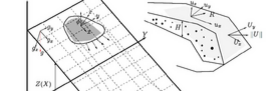
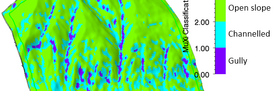
Avalanche flow heights and velocities are calculated on three-dimensional digital terrain models. Single or multiple release areas are easily specified using GIS type drawing features. Users are provided with useful overview information of simulations, including all-important information of the release area (mean slope, total volume), flow behaviour (max flow velocities and heights) and stopping behaviour (mass flux). Maps and remote sensing imagery can be superimposed on the terrain models to aid the specification of input conditions and calibrate the model with known events.